Sunday, May 12, 2013

Beaumont 1905

Beaumont, Kansas from the Kansas Atlas of 1905
The Standard Atlas of Butler County, Kansas, 1905, contains the plat map for Beaumont, Kansas as well as for all the townships and cities of Butler County.

John Finley Van Huss (born 1859, Elizabethton, Tennessee) is the great grandfather of Robert Van Huss. He settled in Butler County in 1885, purchasing a claim near his brothers in Glencoe Township for 160 acres from the Osage Trust. This deed is found in the Register of Deeds office in the county courthouse in El Dorado, Kansas.

On June 4th, 1903,  John Finley Van Huss purchased four lots in Beaumont by tax deed. The deeds are for lot 2, block 5 of Cooper's Addition; and for lots 6 and 7 of block 5 of Summit, and lot 10 of block 6 of Summit.

Beaumont 1905 Kansas Atlas


I have also included a portion of the map revealing the location of the old round house. Note the residence of Dr. William James Phillips, bob's maternal grandfather and the Beaumont town doc.

Latham Kansas 1905
I haven't yet found an image of Beaumont Kansas in 1905. Instead, I have one from Latham, a town where J. F. Van Huss bought lots in 1902.


Van Huss

Approaching Beaumont, Kansas from the west on Highway 400, just before you get to Beaumont, look to the left and there sits 480 acres of land (or is it 640 acres?) which once belonged to four or five brothers with the last name Van Huss. I say four or five because I am uncertain of the property records found in the county courthouse in El Dorado. The claims are there, reflecting the purchase of land from the Osage Indian Trust, but the deeds were filed over several years, and there was a little give and take between brothers.

This  land is pasturage, lying as it does at the top of the Flint Hills between Butler and Greenwood counties. The Google Map of the property shows the beginnings of a creek that eventually becomes the Little Walnut River.

One can walk the land and find a stone foundation for a house long gone. Near by stands an iron pump made in Rockford Illinois.

Google Map Glencoe Township


In the early days of my marriage, my wife's family would make numerous Sunday outings to Beaumont. We traveled by car from Wichita, heading east past Augusta, then Leon, and out into the treeless Flint Hills. Today, the trip takes perhaps 40 minutes, and in Beaumont, you can enjoy the serenity of the Flint Hills and good food at the historic Beaumont Hotel.

In olden days, we went on the Sunday before Memorial Day. First, there was a visit to the Beaumont Cemetery and the family graves. Then we enjoyed a softball game in Bob's front yard - Bob owned two houses on Main Street. Occasionally, we made a short fishing trip to the local pond where the fish never seemed to bite.

In Beaumont, my wife's father, Robert (Bob) Van Huss kept two homes. They were not grand homes, Beaumont has few of those, but they were sturdy, attesting to the values of the early settlers. Among those early settlers were Bob's father and grandfather who arrived by covered wagon and horse in the 1870's.

Bob proudly mentioned that his grandfather on his mother's side, Dr. James W. Phillips, was the doctor for Beaumont and the Frisco Railroad, which made Beaumont a hub. He also spoke of the farm that his father's father once had off to the south and east of Beaumont. But never did I hear him speak of land to the north of Beaumont. So, what am I to think of this Butler County Atlas of 1885, which identifies a Van Huss owning 480 acres.

Detail of Kansas Atlas, 1885, Butler County, southeast corner of Glencoe Township

The property is pasture land today. The land drains from the south and north into a creek which crosses the land to the west, eventually forming the Little Walnut River near Leon, Kansas. A dike at the west end of the property forms a lake that centers on Summit Road.

I parked the car just off Highway 400 and on Summit Road, just before one gets to the lake. I took the dogs Sammy, a German Shepherd, and Tobie, a Australian Shepherd and Mountain Cur mix, on a walk. The cattle were gone, but they had left reminders of their presence.  We headed east avoiding the cow droppings early settlers prized when their was no wood to be found. One can follow the shallow creek bed or head out into the field which still contains chert here and there. It is the chert, which settler called "flint" that gives the area its name, the Flint Hills.

On the south side of the creek is an old pump and the stone outline of the foundation of a building. Perhaps, it is the house of old man Van Huss and his family.

Looking east toward Beaumont, property of old man Van Huss


Notes.

1. If you examine the map for Glencoe Township, you will notice the initials "J.W.P" which in all certainty stand for James William Phillips.

2. The pump is made by Ward of Rockford, Illinois. I can't seem to find out much information on the pump other than a listing for "Ward Pump Co. Manufacturers of Iron Pumps and Cylinders. Frank Ward, President. Frank Lane, Secretary" from a map of Rockford, Illinois, 1891.


Ward Pump, Rockford Illinois
Now I need to go back to the Register of Deeds Office in El Dorado, Kansas amd search the title records for this property.

Beaumont Cemetery

Beaumont cemetery is one of two cemeteries in Beaumont, Kansas. It lies at the northeast corner of the city on the north side of Highway 400. The cemetery is perhaps an acre in size. It is the resting place for almost 200 souls. (Beverly Horner has recorded the names of 194 individuals in the Beaumont Cemetery. See Interment.net.)

The cemetery serves the pioneer families who settled Butler County near the headwaters of the Little Walnut River. This includes the townships of Glencoe and Hickory and the city of Beaumont. Included in those families are the ancestors of Robert and James Van Huss and their extended families. Other families include the Phillips, Edgars, Ferrells, Wassons, Northingtons, Axtells, Burrises, and Robinsons, to name but a few.

The date of the cemetery's opening is unknown, but early tombstones include  Elizabeth Wails (died January 8, 1887, age 56, 4 months, 21 days)  and Thomas Wails, (died December 17, 1887, age 59, 4 days). *

Thomas Wails, Beaumont Cemetery, died 1887


Settlement of Butler County and the Walnut River Valley began as early as the 1850's, but title to land was always uncertain until the final removal of the Osage and other tribes, which did not take place until the early 1870's. ** The historic Beaumont Hotel was built in 1879, and previous to that the location served as a stagecoach stop for the route between Fredonia and Wichita, Kansas. The post office came to Beaumont in 1880. And in 1885, the Frisco railroad come to town, connecting St. Louis to the east and Wichita to the west. Beaumont served as a refueling and service center. Its location at the top of the climb though the Flint Hills and Greenwood County making it ideal.

If cemeteries could speak they would reveal countless tales of heartbreak and sadness. For instance, there is the headstone of Orville and Mary Northington. Orville lived from 1889 until 1969. His wife Mary Kellie from 1890 until 1967. Next to their beautiful granite headstone are three well-preserved concrete headstones marking the deaths of Clara Northington, born May 15, 1934, died May 19, 1934; Irene, born November 25, 1931, died July 22, 1934, and; Oliver, born September 1930, died January 1932. Their stories are lost to time, but it is well to remember that Kansas in the 1930's was a decade of drought and dust storms.

Clara, Irene, and Oliver Northington, Beaumont Cemetery


*William Thomas Wails had at least one daughter, Mary Ann Wails (1883 - 1962).  She was born in Beaumont, Kansas, USA on 1883 to William Thomas Wails and Lettie Jane Mead. Mary Ann married John Oscar Strader and had 8 children. Ancestry.com.

** The Osage Indian settlements in southeast Kansas were primarily in Montgomery County, near present day Independence. However, the Osage Indians crossed Butler county in a well marked trail on their way to hunt the plains buffalo. Read more about the Indian Reserves in Kansas.

Wednesday, April 10, 2013

The Great Dakota Boom

There will always be questions and questions will always remain unanswered. The question is why Frank and Fannie Miles settled in the Dakota Territory sometime before 1880 and why they left. Frank and Fannie Miles are the great-grandparents of my wife, and the grandparents of Charlie Miles, Mary Van Huss, and Joan Smith. They are the great-great-grandparents of my children Hannah and Will Davis.

1880 US census, Dakota Territory, Virginia Township, Union County


The 1880 US Census records the fact that Frank Ottley Miles, his wife Fannie Brewster Miles and their one-year-old daughter Hattie lived on a farm in the southeast corner of Dakota Territory, Virginia Township, Union County. The farm was in the James River Valley north and east of Yankton. The census record is hard to read so I have cropped the image to reveal the names of Charles, farmer, age 27, Fannie, keeping house, age 21, and Hattie, age one. Hattie's place of birth is Dakota, so we know that the Miles family came to the Dakotas before 1879.

detail of 1880 US census

The land that the Miles family settled was formerly land owned by the Sioux. In 1858, the Yankton Sioux signed the 1858 Treaty, ceding present-day eastern South Dakota to the United States.

Middle Missouri River by Lewis and Clark, pub. 1814

Detail of Lewis and Clark map of the middle Missouri River, image from Wikipedia. The annotations states that between the Jacques [James] and Sioux rivers, "the different bands of the Sioux Indians meet each Spring to trade with each other and with white Traders who visit them."

Question: When did Frank and Fannie Miles arrive in Dakota territory?

In truth, I don't know. Nor do I know when they left, although I do know by the time of the 1900 census, the family moved on to Oklahoma where they again took up farming near Stillwater. The answer to both \questions should lie in the court records of the county where they lived. There the Register of Deeds would have recorded the Homestead claim that was filed, for a fee of $14, and the subsequent sale, when the family moved on to Oklahoma.

Question: What did Frank and Fannie find when they moved to the Dakotas?

The simple answer is not much. In 1880 there were few towns, few railroads, the James River Valley was just a flat fertile stretch of land that was eagerly sought by homesteaders. So eager were farmers for land in the Dakotas that between 1880 and 1890, the population of the entire Dakota Territory, both south and north, jumped threefold from 135,000 to over a half a million souls. They came, for the most part, with not much in their pockets. They through up simple frame house, or sometimes a sod house, where wood or money was scarce, and commenced to farm. To give one a sense of the magnitude of the land rush, consider that in 1880, when Frank and Fannie had already established their claim, almost 3 million acres were filed on. By 1884, this figure rose to over 11,000,000 acres. Read The Farmers' Frontier, 1865-1900, by Gilbert C. Fite, for a good discussion of the Dakota Land Rush.

Question: How did they fare?

There are no diaries or personal records of the young Miles family that record their years in the Dakotas. History records a great blizzard that first stuck in October of 1879 and continuing on throughout winter, dropping over ten feet of snow. School children were caught unawares by the sudden October snow storm and hundreds died of cold. The late spring that arrived eventually melted the snow and turned the flat James River Valley into an ocean of water. Still, new immigrants came. And those that survived the winter and the floods prospered in the early years. Bountiful rains throughout the early 1880's meant good crops, usually wheat, but also corn, rye, and barler, which allowed the farmer to earn a good living for his family.

By 1884, the Miles family had a new addition, a baby boy named Charles Dalles Miles. He was born in Sioux City, Iowa. That he was born there might suggest that the farm had been abandoned, or it might simply mean that Fannie had returned to Iowa to be near family or a hospital.

The Dakota land boom continued in 1885 and 1886 with new farmers arriving plowing up the tall prairie grass where buffalo once grazed and planting cereal grains instead. The year 1886 was to be a watershed, when drought again returned to the prairies and falling wheat prices aggravated plight of the farmer. In 1889, statehood finally came to North and South Dakota. Even then, by 1889-1890, the drought affecting the mid-west had become so bad that land that previously yielded 20 or more bushels and acre, were now down to 2 bushels or less. And, by the early 1890's, carloads of coal, food, and clothing was directed from the east to aid the struggling farmers and their families. Accompanying this natural disaster was the economic Panic of 1893. As a result of the bank panic, railroads which had been overbuilt, collapsed, banks which lent money on risky investments collapsed, wheat prices the source of the farmers income collapsed, mortgages were called, and farms foreclosed.The Panic of 1893 was, at the time, the worst depression experienced by the United States.

Some farmers, like the Miles family moved on, some adjusted by changing their farming practices, resorting to livestock, irrigating, or just plain luck of a fortunate rainfall, bringing in a crop. But all those families, like the Miles family demonstrated a desire to make something of nothing, to settle down and create a new life.

Read:
1.  History of Union County, Dakota Territory
2.  History of South Dakota, pub. 1915
3.  Digital Library of South Dakota
4.  History of Dakota Territory, by George Kingsbury, pub. 1915.
5.  A History of Union County, South Dakota, to 1880

Tuesday, April 2, 2013

Beaumont, Kansas

Beaumont, Kansas was once a stagecoach stop on the route between Fredonia and Wichita.

In 1879, it was there, at the top of a steep grade at the northeast corner of Butler County, bordering Greenwood County, that Edwin and Emma Russell built the Summit Hotel. The hotel remains, now rebuilt and renamed the Beaumont Hotel.

The name of the stagecoach line eludes the records - there were many that operated in Kansas after the Civil War, including: The Butterfield, Southwestern Stage Company, the Fort Scott Stage Company, the Southern Kansas Stage Company, and others. Skyways. The stage itself was pretty much the way it is depicted in old western movies, a rocking cradle pulled by four horses. On top rode the driver and one carrying  a shotgun for protection.

Those extolling Kansas and its climate wrote:

The climate is good. The atmosphere is clear and dry and of remarkable purity. Winters are said to be dry and very short, and cattle can graze out nearly the whole year. The heat of the summer is moderated by the pleasant zephyrs which continually sweep across the broad prairies.
 
Winfield Messenger, August 30, 1872.

Southwestern Stage to Winfield, Kansas
Those who knew the truth, mostly kept it to themselves. But Kansas in the early years was subject to prairie fires, drought, locusts, and the vicissitudes of life.

Read a bit of Mark Twain's Roughing It, an account of his trip by stagecoach.

The Frisco

In 1885, the St. Louis and San Francisco Railroad, better known as the Frisco, established Beaumont as a railroad town with a water tower and engine house. For a short time afterwards, it was a collection point for cattle shipped back east.

Beaumont, Kansas Railroad terminus 1918

Today, the railroad is gone, as are most of the cattle, and many of the people who serviced the railroad and the cattle industry, but Beaumont continues on as a private airstrip for pilots who want to fly in on the week-end.

Sunday, March 31, 2013

Charles D. Miles


Charles Dalles Miles, born in Ohio, July 1852, is the father of Frank O. Miles, and grandfather of Mary Miles, who is the wife of Robert (Bob) Van Huss.

Charles, like the majority of males in the United States in the second half of the 19th century, was a farmer. He first tried his luck in the Dakota territory around 1890, then, sometime later, moved on to Oklahoma, first near Stillwater and Payne County, then near Morrison, Autry Township, Noble County. He then moved to Arkansas before returning to Oklahoma, to be near his daughter Hattie. He and his wife Fannie May (Brewster) Miles are buried in the nearby Morrison cemetery.


Little is known of Charles other than the few facts that can be gleaned from the four US census records where his name appears. These records are from the following decades: 1880, 1900, 1910, and 1920 (the records of 1890 were destroyed in a fire). Even though Fannie died in 1935 and Charles in 1943, I have found no other records for them.

1880

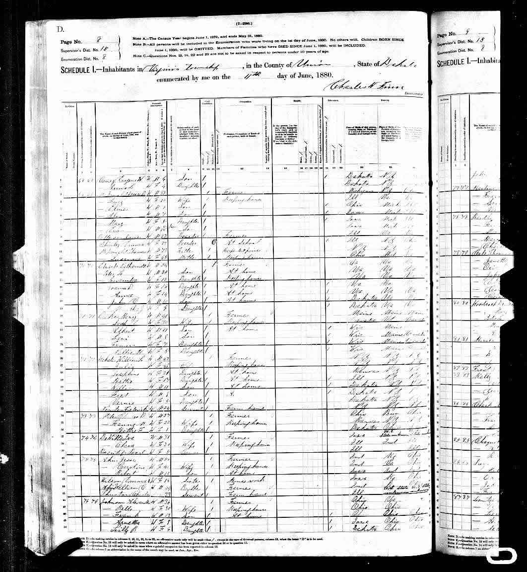
The census record of 1880 reveals that Charles, then aged 27 and his wife, Fannie M., 5 years his junior, were living in the territory of Dakota. Statehood would not come until 1889. The census records the location as Virginia Township, Union County. The location is just north of Sioux City, Iowa and near the present town of  Hawarden, South Dakota. See Map. Charles and Fannie had, at the time, one daughter, Hattie F., who was then only one year old. Charles farmed while Fannie kept the house.

The other few tantalizing facts revealed by the census include Charles' place of birth, Ohio, and those of his father and mother, Pennsylvania and Ohio. Fannie's place of birth was Kansas, and those of her father and mother, both of New York.

US Census 1880 for Frank and Fannie Miles
The young Miles family had to endure the Hard Winter of 1880-1881. Snow fell in October and over the succeeding months, accumulated to over ten feet. When  a late spring finally arrived, the snows melted turning the flat prairie into a giant lake.

There are too many coincidence of name to mention them all. But, it seems appropriate to say a little about General Nelson Miles. As Nelson Miles was originally from Massachusettes, it is unlikely that there is any direct family connection.

Following General Armstrong Custer's defeat at the Battle of the Little Big Horn in 1876, General Nelson Miles was dispatched to track down Sitting Bull. The cause of all the trouble was the discovery of gold in the Black Hills of the Dakota territory. The Sioux naturally resisted the white man's incursions and war followed. The area where Charles and Fannie settled was the historic home of the Yankton Sioux.


1900

The census of 1900 places the family in Stillwater, Okalahoma, in Payne County. Frank and Fannie are now 47 and 42 years old, and one son, Frank O. Miles, age 16, born in Iowa, lives with them. (Note, the census record incorrectly lists Charles' father as being born in Ohio.)  Eleven year old Hattie is missing from the census. Son, Charles is helping on the farm. Charles owns his farm, but it is mortgaged to the bank.

US Census 1900, Frank and Fannie Miles

1910

Ten years later, when the census of 1910 is taken, the Miles family has moved to Noble County and Autry Township. Charles and Fannie are now aged 52 and 47; and, the household has again changed. Both children, Hattie and Frank are now gone. But there is the mysterious appearance of four new individuals. These are daughter, Elsie M. Duree, age 28, divorced;  granddaughters Alpha A. and Hattie O., ages 7 and 5, and a hired-man, Sirie Crits, age 21.

Now I said that both Hattie and Frank had left the household, but then, who is Elsie M. Duree?  And how is it that the 1910 census says that Charles and Fannie are only 5 years older than the 1900 census? Shouldn't they be 57 and 47, respectively?

One has to be mindful that census recorders can err. Then too, we all like to lie about our age, and shaving five years off is not an uncommon thing.

The bigger mystery for me is, "Who is Elsie M. Duree?"

Hattie, Charles and Fannie's daughter, was 31 years old in 1910. She appears on another 1910 census record, and married to Allison (A) A. Hileman. Hattie died and was buried in the Morrison cemetery in Oklahoma alongside her husband.

[Charles Dallas Miles and Frances May Miles are also buried in the Morrison cemetery.]

Could it be that Elsie is a third child?

The 1910 census records that Fannie had four children, three of whom were living at the time the 1910 census was taken. Don't know, but this is the first and last time Elsie's name appears. Need more research.


US Census 1910, Frank and Fannie Miles
1920

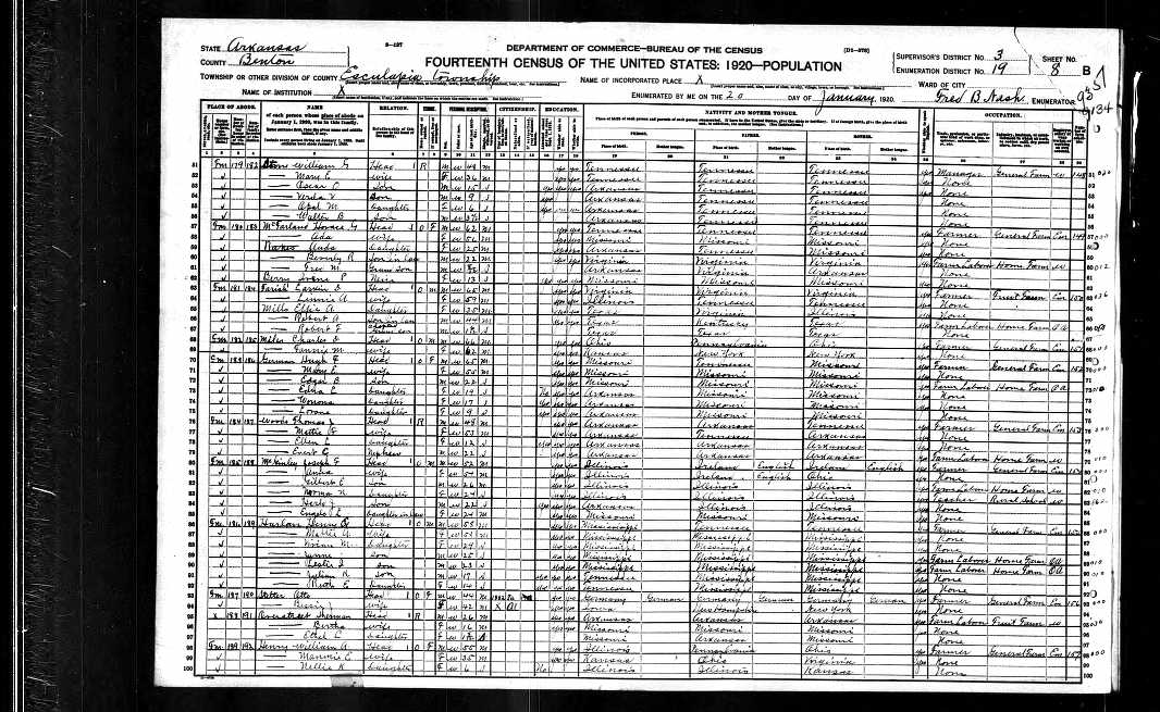
By 1920, Charles and Fannie, now living alone and listed at the ages of  66 and 62,  have moved on to Esculapia Township, Benton County, Arkansas. Charles is still farming.

US Census 1920, Charles and Fannie Miles


1940

The 1940 census records that Charles Miles, age 86, was living with his daughter Hattie, age 61, and her husband A.A. Hileman in Otoe, Pawnee County, Oklahoma. [I haven't seen the record.] The reference to Otoe, an Indian tribe related to the Sioux, fuels the family lore that the Miles family is part Indian.

Morrison Cemetery

The Morrison cemetery records Fannies's death as 1935 and Charles in 1943.


Saturday, March 16, 2013

Frank Miles in the 1920's

I have already written that Frank Miles went to the oil fields in French Algeria where he met his wife to be, Maria Llabres. They married and,

"...in November of 1925, Frank, his wife Maria, and baby son Charles left Bordeaux [France] for New York aboard the French liner Le Bourdonnais. They settled in Spring Township, Butler County where they remained for the rest of their lives raising their three children Charlie, Joan, and Mary. Maria would remain on the farm with one exception, a trip that she took with her daughter Mary in the late summer of 1954 when she traveled back to France and Algeria to visit relatives."
Arriving as they did in 1925, the small Miles family just missed the devastating tornado of 1924 which struck Augusta Kansas.

Augusta tornado 1924, Bob Bergman
No luck in identifying the nature of the Snodgrass building. A Snodgrass genealogy lists R.L. Snodgrass of Augusta, Kansas, but identifies him as a farmer.

The Miles family grew up near the small community of Haverhill. The son Charlie and the two daughters to come, Joan and Mary (born Mary Maria Miles in 1931), went to school in Leon, walking the dirt road two miles there and back each day. Frank continued to work as an oilman, but it is unknown which company he worked for. It could have been for any of the several refineries in El Dorado, but then it could have also been for one of the three refineries in nearby Augusta.

Oil derrick circa 1920

Photograph from Kansas Memory - Mr. Eliga Carter at Gordon oil field, El Dorado, Kansas.

There is precious little to know of the decade of the twenties. Today, one traveled from Wichita to Augusta in fifteen minutes, but the trip took planning. Not until 1924, was a two lane brick road laid between Wichita and Augusta. Beyond that to Leon and Haverhill where the Miles lived, and to Beaumont, where the Van Huss family lived were dirt roads, impassable when it rained.

The 1920's were a time of change for cities. The streets were paved, and street lights put in. Small grocery stores popped up. Many a lad got his first job stocking shelves with goods and carrying out bags for customers. State law closed businesses on Sunday. Local bands provided weekend entertainment.

Cinemas came to town in the 20's. And the popular movies of the 1920's were such fare as "The Perils of Pauline" and "Buck Rogers" and westerns, like those of William S. Hart and Tom Mix. Not until 1927, did talkies first appear with Al Jolson in the "Jazz Singer."


Cars which had only made their appearance 20 years earlier, now edged out the horse and buggy on the streets and roads. In 1927, Henry Ford watched the 15 millionth Model T roll off the assembly line. It sold for a whopping $260. The oil industry that Frank Miles worked for, would fuel the growth in automobile transportation.


Sunday, February 10, 2013

Maria Llabrés

Maria Llabrés

Maria Llabrés
Well no, actually, the picture is not of Maria Llabres, but her daughter Joan. And aren't our children a reflection of ourselves in a younger time?

Majorca 1895

Maria Llabrés was born in 1895 on the island of Majorca. Her parents ran a hotel, whose name is lost to posterity, in the resort of Soller. The port of Soller and nearby city of the same name, lie on the southern coast of Majorca. The city is nestled in a wooded valley, famous for its oranges and ancient olive groves.Curious as to what Soller looks like, check out  this blog.

Though the name of the Llabrés family hotel is lost, there is a Fonda Llabrés Hotel in Soller, just off of the main plaza. The hotel is run by the Llabrés family.

Porto Soller Mallorca
Image posted on the internet by several users.

Watch an amusing video on Majorca (Mallorca).

A postcard tour of Mallorca


In 1891 disease destroyed Majorca’s vineyards. Grapes were decimated and the island's main source of income collapsed. From 1891 to 1895, Majorcans emigrated in great numbers. In 1895, Spain was ruled by nine year old King Alphonso XIII and his mother as regent. In 1898, Spain was defeated in the Spanish-American War.

Algeria

The Llabrés family name appears to be Spanish, and there is no explanation of how it became French. But we do know that the Llabrés family went to French Algeria where they took to farming near the town of  Bône, tha ancient city of Hippo, where St. Augustine lived in Roman times.


Kansas

In 1920, Frank Miles, a young oil worker from Kansas, came to Algeria. Frank and Maria met, fell in love, married, and returned to Kansas where they raised a family of two girls and a boy.

Joan is the one in the picture.